Deep-Earth channels may help explain western U.S. uplift, volcanism and mineral pathways
06-08-2026
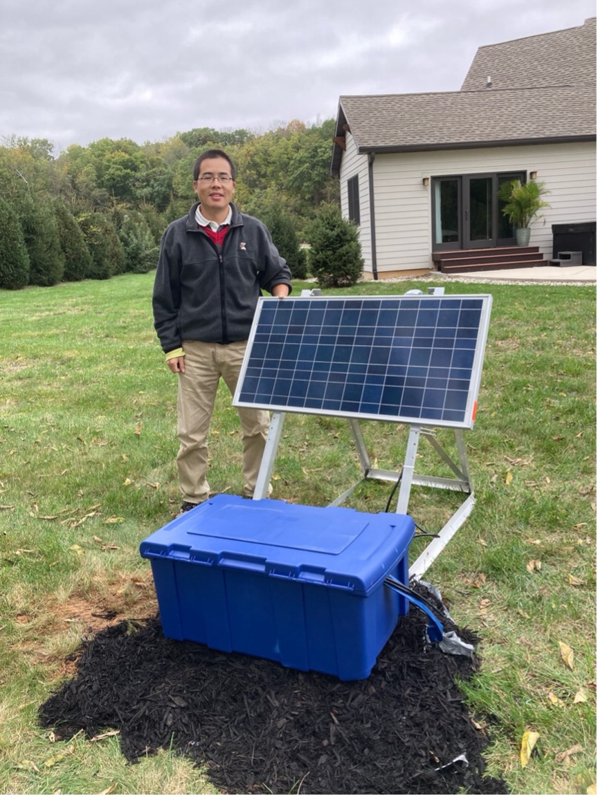
Xiaotao Yang in the field after deploying a seismometer near the Tippecanoe River. (Credit: Xiaotao Yang)
Far below the mountains, plains and deserts of the western United States, ancient continental rock extends deep into Earth, forming a cold, rigid foundation that has helped stabilize the continent for billions of years. Scientists call these ancient continental cores cratons, and their deep roots can plunge more than 100 miles beneath the surface.
But a new Purdue University-led study suggests those roots may not be as permanent as once thought.
"Our discovery is that this deep root isn't as permanent or indestructible as we once thought," said Xiaotao Yang, an assistant professor in the Department of Earth, Atmospheric, and Planetary Sciences at Purdue University. "By listening to the natural background vibrations of the planet Earth, with a technique similar to ultrasound or X-ray imaging in medical examination, we built a high-definition 3D image of what's beneath the western United States, across the edge of the cratonic lithosphere."
The discovery, led by Yang, has been published in Nature Communications. Yang initiated the project, coordinated the work, carried out the seismic imaging processing, formal analysis and interpretation, integrated the results with other datasets and led the writing of the manuscript.
The study focuses on the western margin of the North American craton, where the ancient, thick root of the continent meets younger, thinner and more tectonically active regions of the western U.S. That meeting point creates a sharp underground step in the lithosphere, the rigid outer shell of Earth. The new research suggests that hot, flowing mantle rock below the continent is exploiting that boundary, weakening the craton from the side and carving deep channels hundreds of miles into the stable continental interior.
"Combining with multiple datasets from geochemistry of volcanic rocks and numerical modeling results, we found that the hot, flowing mantle rock beneath the continent is actively eating away the 'stable' root from the side," Yang said. "But it isn't happening in a smooth, even line along the craton margin. Instead, the hot material has punched through the edge and carved out two massive, narrow channels that extend hundreds of miles inward toward the Great Plains. Inside these channels, the rock is being softened and weakened by intense heat and deeply buried fluids."
Yang built a high-resolution 3D shear-wave velocity model of the crust and upper mantle across the western U.S. using full-wave ambient noise tomography. In simpler terms, Yang used natural background vibrations of Earth to image the deep structure below the continent. Seismic waves travel faster through cold, strong rock and slower through warmer, weaker or chemically altered rock, so changes in wave speed can reveal where the continental root is being modified.
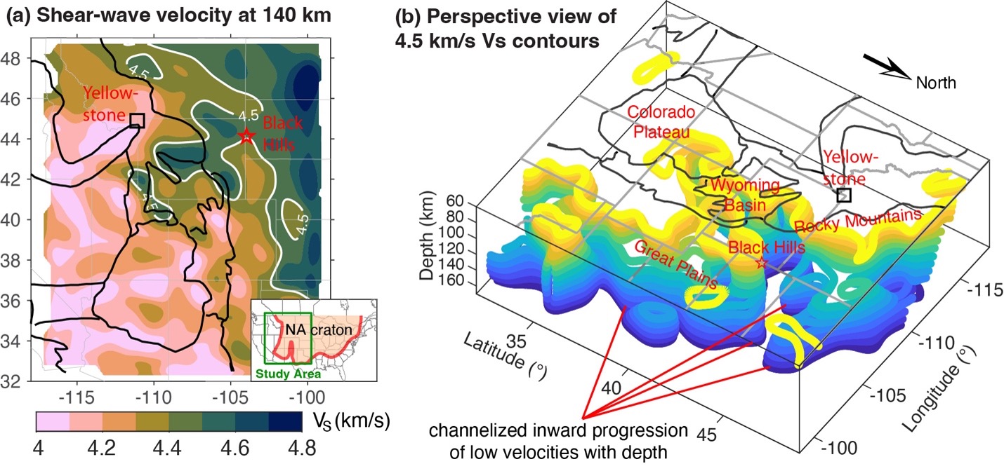
Seismic shear-wave velocity at a depth of 140 kilometers, left, and a perspective view of 4.5 kilometers per second shear-wave velocity contours, right. (Credit: Xiaotao Yang)
The model shows that the high-velocity cratonic keel, or deep root, retreats inward with depth along the entire western margin, not just near the Colorado Plateau, where previous studies had focused. Yang also identified two narrow low-velocity zones, each about 90 to 125 miles wide, that extend about 310 to 370 miles into the craton toward the Black Hills in two different directions. These zones show signs of channelized lithospheric weakening, meaning the deep root is not being eroded evenly, but through focused pathways.
Yang compares the process to a cliff being worn down by the sea.
"To picture what is happening 100 miles beneath our feet, imagine a giant, solid rock cliff facing a turbulent ocean," Yang said. "You might expect the crashing waves to wear down the cliff face evenly over time, but instead, the water finds small cracks, concentrates its energy there, and carves out deep, narrow sea caves and tunnels into the cliffside. This is exactly how the deep Earth operates: the ancient, solid root of the North American continent acts like that cliff, and the hot, flowing mantle behaves like the ocean."
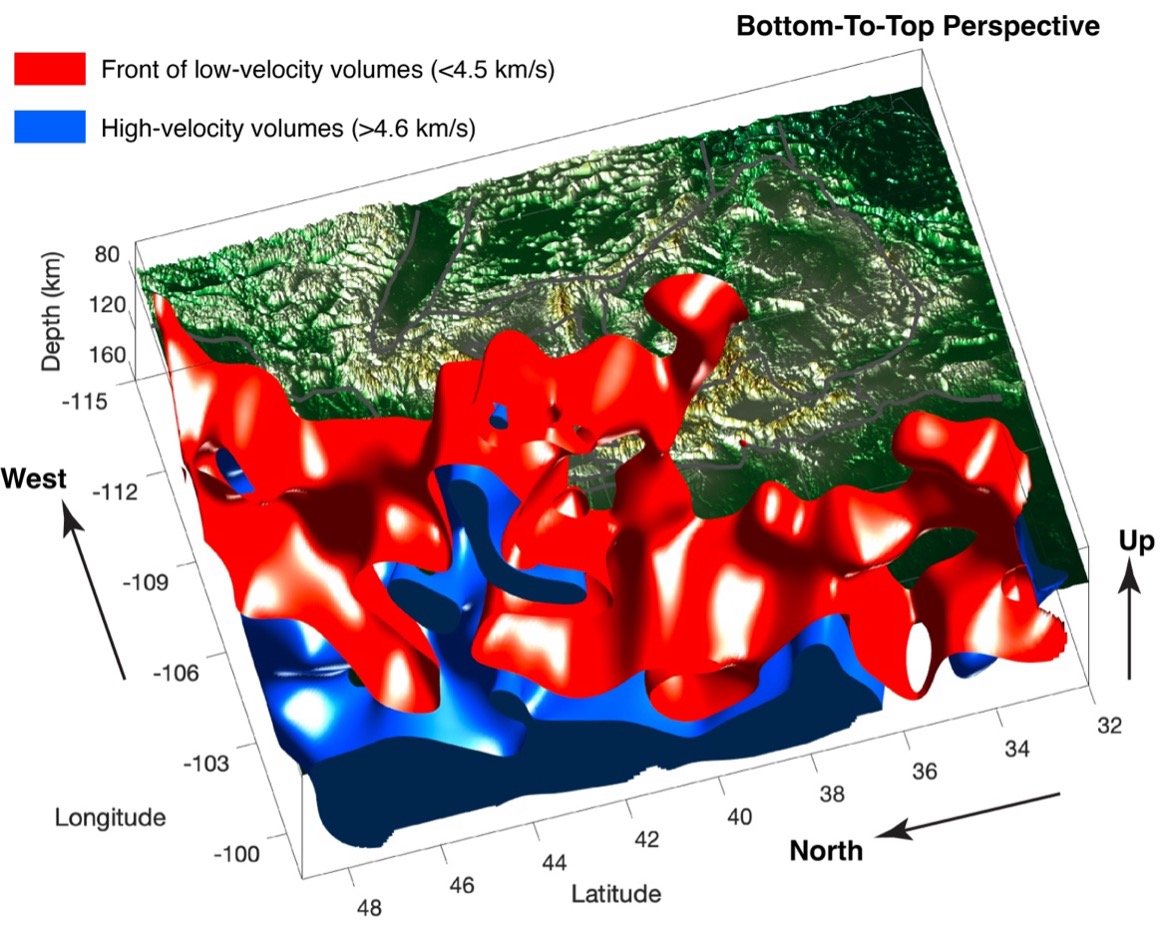
Bottom-to-top perspective view of the “eastern” front of the low-velocity volumes, shown in red, and distribution of high-velocity volumes, shown in blue. (Credit: Xiaotao Yang)
The "ocean" in this case is not water, but hot mantle rock moving below the continent over geologic time. As that material moves against the thick craton margin, it can heat, hydrate and chemically alter the base of the continental root. That process, known as metasomatism, can soften and weaken the mantle lithosphere. Over time, the altered material may become denser and more likely to peel away or sink into deeper Earth, a process called delamination.
"Eventually, with some chemistry reactions, these softened pieces become so heavy that they would tear off and sink into the deep Earth," Yang said. "When that massive weight breaks off from the original lithosphere, the crust above it suddenly gets pushed up by lighter materials below it, with the occurrence of volcanic activity at the surface."
That deep process may help explain some of the most dramatic surface features of the western U.S. The study links channelized erosion of the continental root to regional uplift, including uplift of the Colorado Plateau, and to the migration of volcanic activity across the region over the past few million years.
"This hidden, channelized, deep-Earth erosion is the secret force that has lifted up scenic landscapes like the Colorado Plateau by thousands of meters and dictated where volcanoes have erupted across the western US over the last few million years," Yang said.
The paper also introduces a three-stage framework for how craton margins may evolve. In the first stage, hot mantle flow, fluids and partial melts begin weakening the craton margin. In the second stage, that weakening progresses inward along narrow channels, like the two low-velocity zones identified in this study. In the third stage, the weakened and chemically altered lower lithosphere can thin, delaminate or gradually erode away, allowing hotter, lighter material to rise beneath the surface.
While the study is focused on fundamental questions about how continents evolve, the findings also carry possible implications for mineral exploration and long-term tectonic hazard modeling.
Many critical minerals form or move through systems involving heat, fluids and magma from deep within the Earth. By imaging where deep-Earth channels have carried heat and fluids into the continent, the study may help scientists better understand where valuable ore deposits could be concentrated in the upper crust.
"Because our research maps where these deep-Earth "channels" have funneled fluids and heat into the continent, it provides a brand-new roadmap for exploration," Yang said. "Resource companies can potentially use these 3-D models of the deep craton margin to better predict where valuable ore deposits are most likely to have concentrated in the upper crust."
The work may also improve long-term models of tectonic stress in the western U.S. Although these processes unfold over millions of years and do not point to immediate hazards, they help explain how stress is distributed across the continent.
"Understanding the precise geometry of these deep channels helps scientists better model the tectonic forces acting on the continent," Yang said. "When the deep, heavy root of a continent is eroded and breaks off, it shifts how stress is distributed across the entire region. While this process unfolds over millions of years, mapping these deep structures allows geophysicists to build much more accurate models of regional stability, fault loading, and long-term seismic hazards across the Western United States."
The research was made possible in part by Purdue's high-performance computing resources, which allowed Yang to process massive seismic datasets and run complex imaging methods. Yang co-leads Purdue's Computational Seismology and Tectonic Laboratory, where researchers use seismic data, computational tools and geodynamic interpretation to study the deep structure and evolution of the Earth.
For Yang, the research changes how scientists should think about the supposedly stable foundations of continents. Cratons are strong, old and long-lived, but they are not frozen in time. Their margins can be weakened, carved and reshaped from below, with consequences that eventually appear at the surface as mountains rise, volcanoes migrate and hidden mineral systems take shape.
The work is supported by Purdue University startup funding and National Science Foundation award EAR-2319445 to Yang. Seismic waveform data were accessed through the NSF SAGE data archive operated by EarthScope Consortium under NSF award 1724509.
About the Department of Earth, Atmospheric, and Planetary Sciences at Purdue University
The Department of Earth, Atmospheric, and Planetary Sciences (EAPS) combines four of Purdue’s most interdisciplinary programs: geology and geophysics, environmental sciences, atmospheric sciences, and planetary sciences. EAPS conducts world-class research; educates undergraduate and graduate students; and provides our college, university, state and country with the information necessary to understand the world and universe around us. Our research is globally recognized; our students are highly valued by graduate schools and employers; and our alumni continue to make significant contributions in academia, industry, and federal and state government.
Written by: David Siple, communications specialist, Department of Earth, Atmospheric, and Planetary Sciences at Purdue University