New seismic research helps understand the volcanic activity in Alaska
11-12-2020
Writer(s): Cheryl Pierce
Plate tectonics is a complicated phenomenon which isn’t completely mapped or understood. The Earth’s surface layers move all the time, which can produce volcanic activity where the plates meet. The region that encloses the converging plates is called the “subduction zone”. Seismologists use seismic waves created by the Earth’s movements to study how the Earth looks like beneath the surface. Co-authored with Dr. Haiying Gao in the Department of Geosciences at the University of Massachusetts, Dr. Xiaotao Yang, Assistant Professor in Earth, Atmospheric, and Planetary Sciences (EAPS) at Purdue University, has recently led a publication in the Journal of Geophysical Research - Solid Earth, which uses seismic measuring to determine volcanic activity in Alaska.
“We study how fast a seismic wave travels in a way similar to medical CAT (computer-aided tomography) scan,” says Yang. “This allows us to ‘see’ the Earth and, hence, to know better about how the Earth, as a system, works and evolves.”
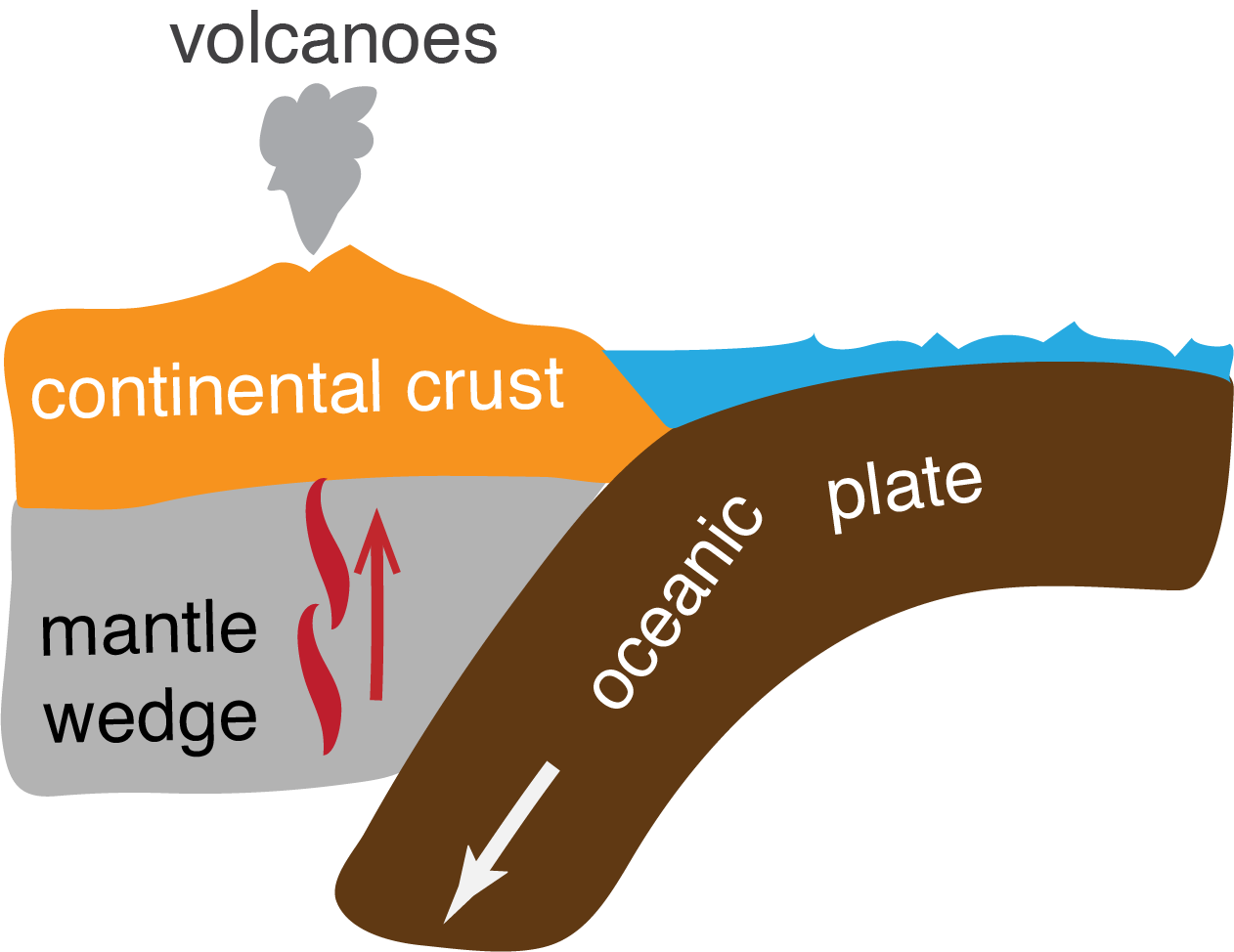
Where plates meet, volcanic activity can happen if a downward tilting plate is under another. According to Yang’s seismic research, an arc of volcanoes can form above the wedge-shape region created by one plate overtop another. An arc of volcanoes in Aleutian-Alaska is the ideal place to study the theory that the wedge caused by converging plates causes volcanic activity. Yang used an advanced seismological method, the full wave ambient-noise tomography, to create high-resolution images of the Aleutian-Alaska subduction zone, where various volcanoes are located. Yang concludes that the shape and physical property (seismic wave speed in this study) of each wedge help determine where the magma resides and how much magma scientists can expect from different volcanoes in that region which could translate to volcanic activity all over the world.
“This work improves our understanding of how complex a subduction zone could be and how this complexity may control the distribution of volcanic activities,” says Yang. “Specifically, our findings suggest that whether there are volcanoes and how the volcanoes are located (circular cluster or linear chain) are partly determined by whether melt is seen and how magma is stored in the crust.”
Yang was attracted to the unsolved geologic mysteries of Alaska after attending a conference in Anchorage, Alaska which motivated this project.
“Besides my long-term interest in studying the Alaska margin and the whole continent there,” says Yang, “this study was made possible by the deployment of a large, dense seismic array across Alaska. It is part of the USArray Transportable Array program, which has finished deploying seismometers across the entire contiguous United States sweeping from the west coast to the east coast.”
The contributions of this paper reach beyond the understanding of the volcano distribution. They also revealed unprecedent details and new features of the Aleutian-Alaska subduction zone. This new structural information implies a highly complicated subduction system, which may give scientists new insights on how an oceanic plate could evolve during the subduction process.
“I have always been intrigued by how the Earth’s lithosphere (the outermost rigid shell) works and how different parts of the lithosphere interact with each other,” says Yang. “A very important component of my research is to understand how the surface processes (volcanoes, earthquakes, mountains, basins) are manifested and controlled by deeper subsurface structures and processes. Along with the deployment of the USArray seismic stations starting 2015, the geologic setting and mysteries of the Alaska margin is the main reason attracting me to this project.”
There are two key oceanic plates (the large Pacific plate and the smaller Yakutat microplate) subducting beneath the Alaska continent. There are also a large number of volcanoes distributed in different geographical locations and in different spatial patterns.
“How do the two subducting plates interplay with each other while they are subducting (going down)? How do they affect the occurrence of earthquakes and volcanoes? These are the questions that have motivated me for this project,” says Yang.
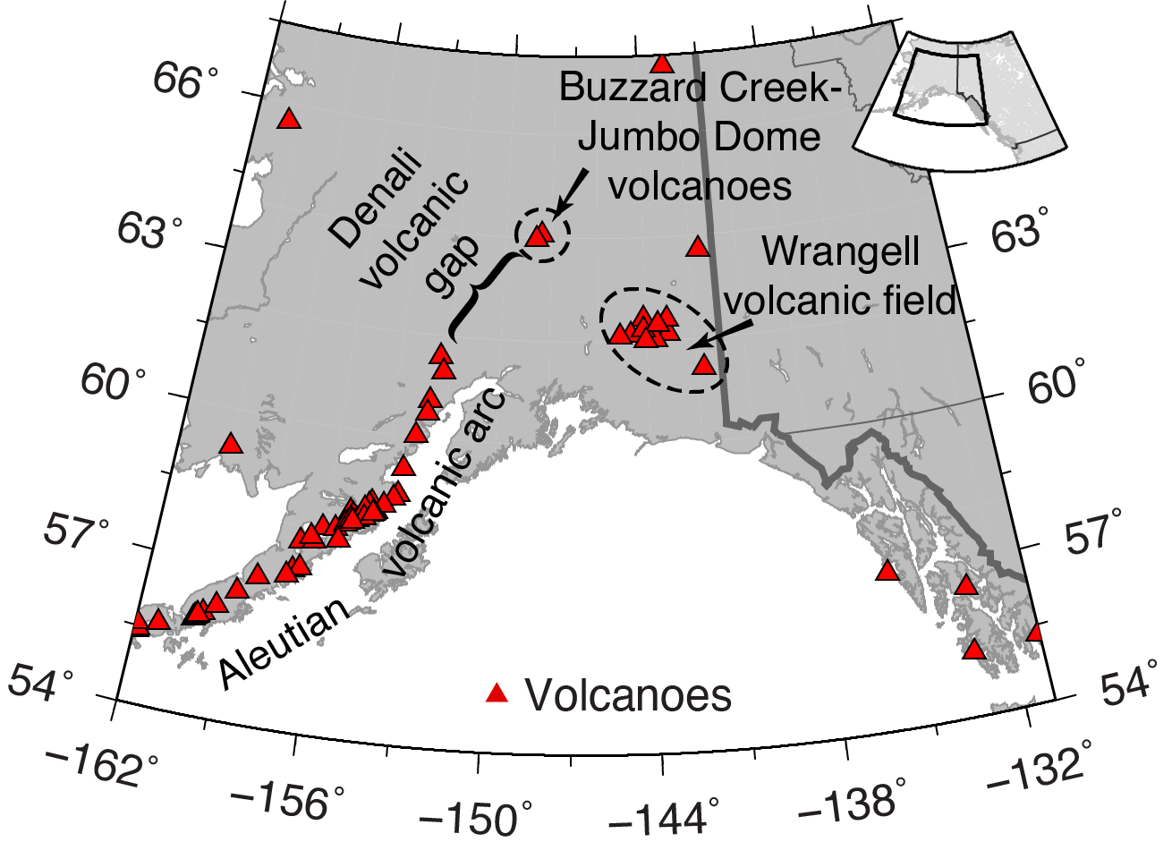
The distribution of major active volcanoes along the Aleutian-Alaska margin.
Not all volcanoes are alike and they can form in varied conditions. Yang’s research dealt only with subduction zone volcanoes, the type that are created when one plate overlaps the other.
“Some of our findings have general implications for subduction zone volcanic activity, though not all volcanic zones (for example, some volcanoes are not directly related to subduction zones, like the Yellowstone volcanoes and the Hawaiian volcanoes),” explains Yang. “For subduction driven volcanic activities, their distributions are not simple, depending on the scale we are looking at. For example, there have been projects in the community studying the Cascadia arc volcanoes, the volcanoes along the South American subduction margin, and the volcanic zones in the southwestern Pacific area. We hope the knowledge we gained from this study could be used to understand the distribution of volcanoes in these areas.”
Yang began this research at UMASS and plans to expand upon it here at Purdue University. He works with other EAPS faculty and students to understand the geodynamic implications of his seismic velocity model.
According to Yang, “Purdue has nationally ranked computational resources (the community computer clusters). The faculty at EAPS are experts in diverse research areas. Combining these with the high-quality students, the unique supports at Purdue EAPS would help me further investigate the dynamics of the subduction process and refine the theories/models on arc magmatism. I look forward to working with colleagues in geochemistry to know more about the magma source compositions and depths. This would further test the theories we proposed in the paper.”
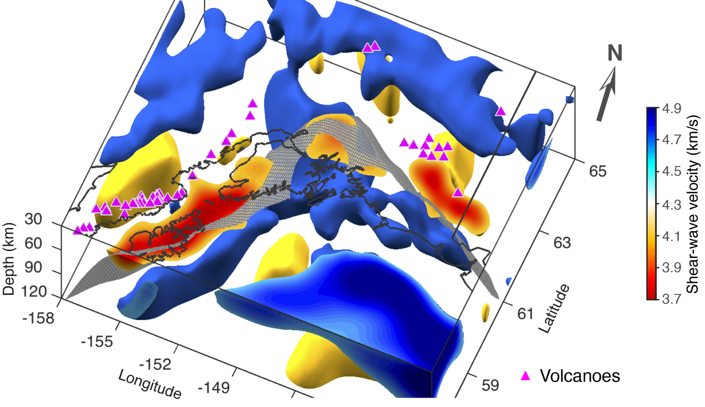
Three-dimensional distribution of major seismic velocity features within the Aleutian-Alaska study area. This is a snapshot showing the high-velocity features below the depth of 30 km (blue patches enclosing velocities ³ 4.6 km/s) and low-velocity features below the depth of 40 km (yellow patches enclosing velocities £ 4.1 km/s). Caps of the velocity patches are color-coded by the velocity values. Active volcanoes (magenta triangles) and the coastline are projected for spatial reference. The gray meshed surface represents the plate interface from model E125 (Jadamec & Billen, 2010). Source data and codes can be accessed on Zenodo (http://doi.org/10.5281/zenodo.3691908).
References:
Jadamec, M. A., & M. I. Billen (2010), Reconciling surface plate motions with rapid three-dimensional mantle flow around a slab edge, Nature, 465(7296), 338-U389, doi:10.1038/nature09053.
Yang, X., & Gao, H. (2020). Segmentation of the Aleutian‐Alaska subduction zone revealed by full‐wave ambient noise tomography: Implications for the along‐strike variation of volcanism. Journal of Geophysical Research: Solid Earth, 125, e2020JB019677. https://doi.org/10.1029/2020JB019677