|
|
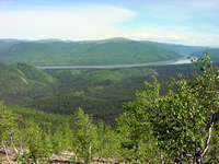
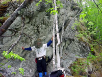
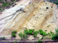
Cretaceous-Early Eocene Development of Yukon Flats Basin, North-Central Alaska New sedimentological and palynological data collected from three outcrop belts along the central portion of the Tintina/Kaltag fault system of east-central Alaska provide an opportunity to understand the history of strike-slip displacement and strike-slip related extension along that fault system. New palynological data indicates that the oldest of these outcrop belts, located along Cheyenne Creek, was deposited during the Late Cretaceous (Maastrichtian). The outcrop belts exposed near the village of Rampart, and along the Yukon River near the Drew Mine, are both Paleocene-early Eocene. Our new data indicate the following two stages of basin development: (1) Maastrichtian: Conglomerate, coarse sandstone, and mudstone were deposited by braided fluvial systems that flowed to the west/northwest. This outcrop belt is enriched in quartz and chert. These strata are interpreted to have been derived from an Aptian/Albian thrust belt located to the east/southeast of the basin. (2) Paleocene- Late Eocene: Mudstone, coal, fine sandstone and conglomerate were deposited by lacustrine systems and eastward-flowing, braided fluvial systems. This petrofacies, dominated by greenstone and chert, is interpreted to have been derived from the Mississippian-Triassic Rampart Group that is presently exposed on the west and northwest flank of the Yukon Flats basin. Maastrichtian strata may be related to extension and thrust reversal
caused by the initiation of strike-slip displacement on the Tintina
fault. These basinal strata, and the thrust belt from which they
are derived,
are proximal to the Charley River thrust belt when ~400 km of post-Paleocene
dextral displacement is restored to the Tintina fault. The second phase
of deposition, represented by the Paleocene-early Eocene strata, may
be the product of extension related to early Tertiary strike-slip displacement
on the Tintina fault. Basin development was coeval with bimodal volcanism,
granite emplacement, and the cooling of metamorphic rocks to the south
of the basin. This stage of basin development is inferred to represent
regional tectonic subsidence that led to the development of poorly
organized, internally drained watersheds with intermittent ponding
of water within
the basin.
|
||||||||
|
Home
| About Us | People
| Research | Facilities
& Resources | Links
Purdue Earth & Atmospheric Sciences Home Page Purdue University Department of Earth and Atmospheric Sciences Civil Engineering Bldg. 500 Stadium Mall Drive West Lafayette, IN 47907-2051 tel: 765 494-3269, fax: 765 496-1210 
|